Wombeyan Caves

Wombeyan Caves

Wombeyan Caves

Hit by the triple disasters of bushfires, floods and Covid, our visit to Wombeyan Caves was not as extensive as we planned. The fires of 2020 damaged the surrounding country severely, removing much of the vegetation. The heavy rain and floods that followed resulted in land slips and damage to all walking tracks. Entry to the Caves has been restricted by Covid positive visitors and most are closed.

However, we were fortunate that the Wollondilly cave reopened the day we arrived, and Fig Tree Cave had remained open. Our planned two-day visit to see three cave systems and walk some of the bush tracks reduced to one guided cave tour and a self-guided trip.

Getting There

The road into the Caves was very narrow at times making us pleased we did not meet any oncoming traffic. Although the road is being repaired and upgraded it will be some time before it is totally fixed.

Accommodation

Camp sites for caravans and tents along with cooking facilities are managed by NSW National Parks and Wildlife. Booking is essential because only limited spaces are available.

Additionally, onsite self-contained cabins and the old post office are available. Again, bookings are essential due to high demand.

We stayed overnight in one of the onsite cabins which although basic was clean and comfortable. With power, air conditioning and cooking facilities, it had everything we needed for a one-night stay. Renovations to the kiosk mean you need to bring all your own food and drinks, because nothing is available at the campgrounds. Remember to bring your own bed linen and pillows too, as these are not provided in the cabins.

Wombeyan Karst Conservation Reserve

Officially proclaimed in 1865, the Wombeyan Karst Conservation Reserve preceded the declaration of the world’s first national park at Yellowstone in 1872. Accessed from the reserve at the base of the valley the caves are in rugged but scenic country.

Surrounded by intrusive igneous rock which metamorphosed the reserve’s 420-million year old limestone into coarse crystalline marble the area has over 500 known caves.

Wollondilly Cave

Fortunately, the Wollondilly system is one of the best available, so we were very pleased to be able to see it. After buying tickets at the NPWS Office we met our guide who took us through 800m of cave.

It has 520 steps spread over five levels varying from concrete and cut marble to vertical ladders. Because the walkways are wet and slippery in places, good footwear is essential.

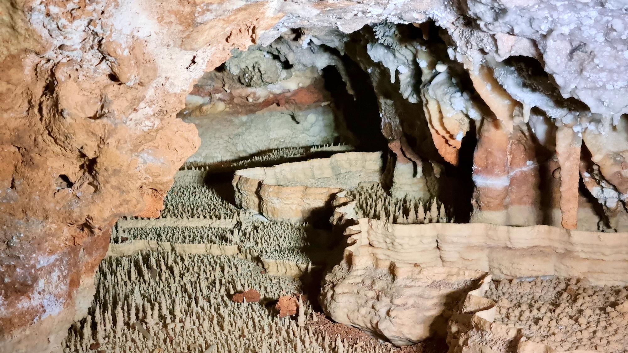
The tour took us through some amazing caverns, with fantastic formations. The most interesting were the rimstone pools, which look like tiny, fortified cities, although the other amazing formations are hard to beat.

Fig Tree Cave

The Fig Tree Cave is a self-guided tour, with stopping points throughout the cave where commentary plays describing the area. Purchasing a double entry to the Fig Tree and Wollondilly Caves is cheaper than buying the two individually.

Possibly the best self-guided caves we have visited, the formations are once again amazing. During our visit, no-one else was in the cave, making it even better, especially after the commentary stopped and it was silent.

The highlight of Fig Tree is the underground river that flows through it, providing a background of noise of running water. The cave’s exit is a huge cathedral-like cavern where the river enters the cave system, before disappearing underground.

Wildlife and Scenery at Wombeyan Caves

The area has a large kangaroo population which spent the day lounging on the grass reserve. Around twilight, they became more active, hopping around and finding food.

The next morning, we had alpacas looking through a neighbouring fence while we ate breakfast.

What Did We Think of the Wombeyan Caves?

If all walking tracks and caves were operating, a two or three-day stay would be needed to see them all. However, with the closures, an overnight trip was enough time to visit the two caves available. Even then the visit is remarkable and worth doing, despite the reduced activities available. We had a great time here exploring the caves.

The only downside was the access road, because it was so narrow in places.

To see what else there is to do in New South Wales, please see some of our other stories.

Our photos are available for purchase on

Heritage Walking Track Minmi

Heritage Walking Track

Heritage Walking Track

Originally a coal mining area dating from the 1840s, little remains to remind you of its past. Following its closure in the 1980s, rehabilitation and dedicated work by the Minmi Heritage Landcare Group have removed many of the scars. Plantings of native trees, the eradication of invasive plants and the installation of barbecues and picnic facilities have produced a beautiful community park. The Heritage Walking Track winds through the regenerated bushland.

Located near the outer western Newcastle suburb of Minmi, the park has plenty of parking and a small toilet block. The walking tracks are shown on an information board near the car park.

The Track

We chose the Heritage Walk because it includes the brick tower of an old ventilation shaft from the coal mine. Starting at the end of the car park, the track immediately splits into two paths. There are no signs to show which way to go, but the correct direction is to the right of the large white tyre. Not far from here, a track leads off to the left. Fortunately, there are two signs here showing that this is the way to go.

From the left turn, the well-maintained path follows a shady route through regenerated Australian bushland. We didn’t see any wildlife but could here plenty of cicadas.

The trail intersects another track, where you will find the brick tower. This remnant of the old coal mine used to provide ventilation to the mine’s underground workings. Turn right at the intersection, where another well-formed track takes you back to the car park.

Only a few minutes’ walk from the car park is the old Minmi Cemetery, where you can see the graves of many of the mine workers and their families.

What Did We Think?

A simple easy walk, it only took us 45 minutes, including stops for photos. The well-maintained path and shady trees made the walk enjoyable.

To see what else there is to do in New South Wales, please see some of our other stories.

Our photos are available for purchase on

Bass Point Reserve

Bushranger Bay Bass Point

Bass Point Reserve

A place of significant cultural value, Bass Point Reserve is Heritage Listed, due to extensive Aboriginal and Colonial use of the area. Archaeological evidence indicates that the Elouera people lived here at least 20,000 years ago. Colonial settlers arrived 1803, although European explorers had passed through before this. Settled by cedar cutters and graziers, much of the area was cleared. Land clearing, disease and hostility by Europeans resulted in the collapse of the Aboriginal population.

The Gravel Loader

One of the first sites you see at Bass Point is the gravel loader which services the local basalt quarry. It forms an interesting contrast to the other more natural heritage areas because of its industrial use.

Bass Point

Walking through the Reserve, we saw some small lizards, but no other wildlife, although larger native animals inhabit the area. The eroded basalt on the shore has places where colourful orange algae grow, adding some colour to the otherwise dull rocks.

US Cities Service Boston & 6th Machine Gun Battalion Memorial

On 16 May 1943, the US oil tanker US Cities Service Boston grounded here during a storm. Australian soldiers from the 6th Australian Machine Gun Battalion camping nearby assisted in the rescue of the 62 crew on board. All lives from the Boston were saved but four Australian soldiers perished in the rescue. Each year, a remembrance service commemorates the loss.

Bushrangers Bay

At the end of Bass Point Tourist Road is a small carpark that services Bushrangers Bay. This beautiful bay has vegetation growing down to the water line. A well-maintained wooden walkway provides access down to the pebble beach.

A viewing platform designed to provide views over the bay sits above and to the left of the steps but was overgrown when we visited. This obscured what would otherwise have been a great view.

Bushrangers Bay is a Marine Reserve, so fishing or removing anything from the area is prohibited.

To see what else there is to do in New South Wales, please see some of our other stories.

Our photos are available for purchase on

Ads Blocker Image Powered by Code Help Pro

Ads Blocker Detected!!!

We have detected that you are using extensions to block ads. Please support us by disabling the blocker.

Powered By
100% Free SEO Tools - Tool Kits PRO