AdBlock Detected

It looks like you're using an ad-blocker!

Our team work realy hard to produce quality content on this website and we noticed you have ad-blocking enabled.

Tanilba Bay Australia

The Water Gates

Tanilba Bay Australia

Located on the Tilligerry Peninsula, Tanilba Bay is a suburb of the Port Stephens local government area in the Hunter Region of New South Wales, Australia.

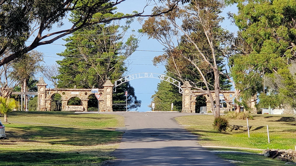
Entrance to Tanilba Bay
Entrance to the town

Tanilba House

The centrepiece of the town is Tanilba House, a beautiful and elegant home which is one of Australia’s oldest historical buildings. Built for Lieutenant William Caswell, a naval officer who had received a land grant of 20.2 hectares in 1831. Caswell established farm sites at Seaham (23 km north) and Salt Ash and opted to build his homestead on the land at Tanilba.

Tanilba Bay House
Tanilba House

The Temple of the Stork

Built from local rock quarried from Mallabula and completed in 1933, The Temple of the Stork is an ornate stone and shell temple. The floor and ceiling of the temple feature reversed images while patterns of 8 appear mystically in the design. Henry F. Halloran who owned Tanilba House at the time was responsible for its construction.

The Temple of the Stork

Water Gates

The Centenary Gate, also known as the Water Gate, were constructed from 1929 to 31 March 1931. It was built to mark the centenary of European settlement at Tanilba Bay by the original grantee, Lieutenant William Caswell.

Henry F. Halloran designed the gate from round and broken quartz porphyry embellished with white feldspar gathered from Tanilba foreshore and a quarry at Mallabula.

The metal arch suspended between the rock pillars reads ‘Tanilba Bay’ and was designed to be viewed from the water when many visitors arrived by boat.

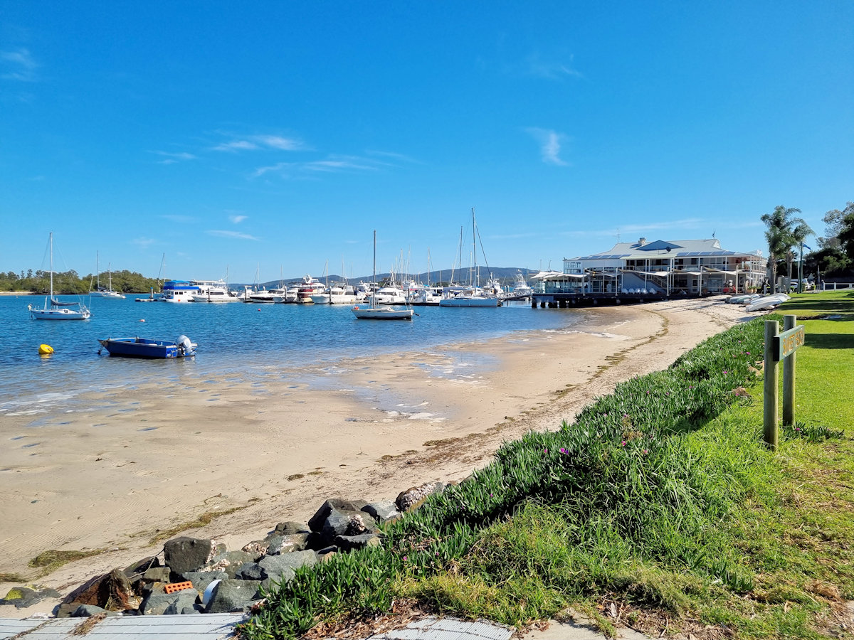
Tanilba Bay Water Front

The town’s waterfront has a nice sandy beach ideal for watersports or relaxing. Bordered by grassed areas with street parking the waterfront is a nice place to stop after arriving. When we visited there was a mobile coffee van in one of the carparks which was great after a 90 minute drive to get there.

Mallabula Beach
Mallabula Beach Looking West
Mallabula Beach Looking East
Looking Over Tanilba Bay
Small sandy Beach at Tanilba Bay
Small sandy Beach
Looking over Tanilba Bay

Tilligerry Habitat

The Tilligerry Habitat and adjacent boardwalk is a great place to wander through. Consisting of rehabilitated sand mining areas, it is now a sanctuary for birdlife and koalas. Unfortunately we didn’t see any on our visit, but we were assured they are there. A longer blog with more pictures of the Tilligerry Habitat can be found here.

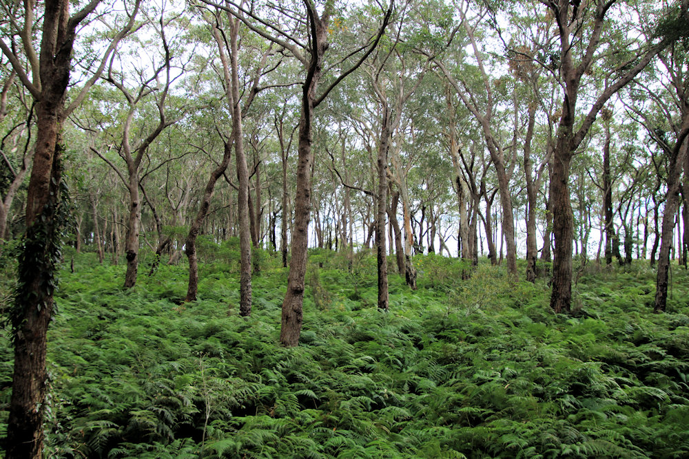
Boardwalk through mahogany paperbark forest Tilligerry Habitat
Boardwalk through mahogany paperbark forest

Our photos are available for purchase on

To see what else there is to do in New South Wales, please see some of our other stories.

Tilligerry Habitat

Mahogany and paperbark forest

Tilligerry Habitat Tanilba Bay NSW Australia

The original sand dunes in what is now the Tilligerry Habitat were subject to deep sand-dredge mining from the 1960s. Removal of the dunes resulted in a flat landscape with the original drainage system damaged and native vegetation cleared. A large section of the disused mine was used for housing and playing fields, but a section remained near the shore along with remnant vegetation.

This remaining section of land was proposed to be used as a caravan park which would have removed the remaining vegetation. However, lobbying by residents enabled its preservation as a reserve for public recreation and coastal environmental protection in 1996. Since then, local volunteers have spent numerous hours re-establishing drainage water flow and replanting trees and built a boardwalk. The result is an amazing area where birds and koalas thrive.

Getting There

We parked in the Peace Park carpark in Tanilba Bay which is only a 5-minute walk from the start of the boardwalk. Parking is also available along Peace Parade and at the Tilligerry Habitat Office.

Tilligerry Habitat Boardwalk

The disturbance caused by the sandmining has left the area generally flat which means that the boardwalk is also very easy to walk. Raised slightly above the forest floor so as to enable water drainage, the boardwalk is very well maintained and there are bench seats to stop at along the way. These give you a nice place to sit while enjoying views through the forest or over the bay.

Along the paths, information boards detail the vegetation growing nearby, with pictures pointing out individual species. The transformation from a sand mine to restored paperbark forest and swamp mahogany is amazing. The volunteers’ efforts have really paid off, resulting in several environmental awards.

Koalas inhabit the area, but we didn’t see any during our walk. However, we did hear the birds, which were very vocal as we walked through the trees giving us a great welcome to the area.

This was a great walk, with the boardwalk winding through the trees. Highly recommended if you are visiting the area.

Our photos are available for purchase on

To see what else there is to do in New South Wales, please see some of our other stories.

Stockton Bridge Newcastle Australia

Stockton Bridge title

Stockton Bridge Newcastle Australia

Spanning the North Channel of the Hunter River, the Stockton Bridge connects the Tomaree and Tillegerry Peninsulas with Newcastle, Australia. Replacing an earlier vehicle ferry from Stockton to Newcastle (the passenger ferry still runs), it has significantly improved vehicle flow. When opened in 1971, it was the longest bridge (at 1,024m) to have been built by the Department of Main Roads and the second longest bridge in New South Wales after the Sydney Harbour Bridge.

We have driven over the bridge many times and always assumed the central barricades were to separate traffic and prevent cars crossing into oncoming lanes. Having wondered how pedestrians crossed, because there are no footpaths on the outside edge, we did some research. It turns out that the bridge design incorporates a central footpath which you access from underneath the bridge.

Getting There

To have a look for ourselves, we parked near the boat ramp and walked across. Located where the bridge meets the ground, the stairs are easy to find. From here it’s a short climb to the bridge surface. While walking across, you are only separated from the traffic by a metal barricade. Although this is sturdy, it can feel unsafe at times as the cars and trucks drive past.

It was a cold clear morning when we walked across, so the views back over Stockton and Newcastle were beautiful. However, as you are in the centre of the bridge taking good photos is difficult because the bridge gets in the way.

Returning to our car, we found some artwork on the concrete uprights near the road. Sponsored by the NSW Government and local Rotary Club, they were a nice colourful surprise.

Our photos are available for purchase on

To see what else there is to do in New South Wales, please see some of our other stories.