Tag: lookout

  • Carradah Park Sydney Australia

    Carradah Park Sydney Australia

    Carradah Park Sydney Australia

    History of the Site

    The BP refinery at Carradah Park in Waverton has a rich history that dates back several decades. Here is a brief overview of its historical significance:

    The refinery was established in 1926 by the Anglo-Persian Oil Company, which later became British Petroleum (BP). Its location in Waverton, a suburb of Sydney, Australia, was strategically chosen for its proximity to deep water, which facilitated the transportation of crude oil.

    During World War II, the refinery played a crucial role in supporting the Australian war effort. It supplied petroleum products to the military and contributed to the nation’s energy security. The refinery expanded significantly during this period to meet the increased demand.

    In the following years, the refinery underwent several upgrades and modernizations to improve its efficiency and environmental sustainability. It became a key player in the Australian petroleum industry, supplying a significant portion of the country’s fuel needs.

    However, as environmental concerns grew, the refinery faced criticism for its impact on the surrounding area. Issues such as air and water pollution led to community protests and pressure for improved environmental practices.

    In 2012, BP announced its decision to close the Carradah Park refinery due to economic factors. The closure marked the end of an era for the facility, and its refining operations ceased in 2014. BP shifted its focus towards fuel importation and distribution in Australia.

    Since the closure, the site has undergone a transformation. The refinery land has been repurposed for various purposes, including commercial and residential developments. The redevelopment has aimed to restore and revitalize the area while preserving its heritage.

    Current Use

    Carradah Park in Waverton has undergone a remarkable transformation in recent years, thanks to the rehabilitation efforts carried out on the site previously occupied by the BP refinery. The rehabilitation process aimed to restore the natural beauty and ecological balance of the area, making it a welcoming green space for both the local community and visitors to enjoy.

    One of the primary goals of the rehabilitation was to address the environmental impacts left behind by the refinery. Extensive remediation works were conducted to clean up contaminated soil and water, ensuring the preservation of the ecosystem and the safety of those using the park. This process involved the removal of hazardous substances and the implementation of sustainable land management practices.

    During the rehabilitation, the focus was not only on remediation but also on the enhancement of biodiversity. Native vegetation was reintroduced, creating habitats for various plant and animal species. This has not only contributed to the park’s aesthetic appeal but has also promoted a healthier ecosystem by attracting local wildlife.

    Furthermore, the park’s infrastructure underwent significant upgrades to improve accessibility and provide amenities for visitors. New walking paths, seating areas, and picnic spots were established, encouraging people to explore the park and take advantage of its recreational opportunities. The inclusion of sustainable features, such as rain gardens and water-efficient irrigation systems, further reflects the commitment to environmental responsibility.

    How To Get There

    We travelled by train to Waverton Station because parking in the area is limited. Walking from the station, we stopped at Botanica Garden Café for a coffee before heading to Carradah Park via Waverton Park.

    Carradah Park

    Walking through the park, information boards explain the area’s past. It’s amazing how much work has been undertaken to transform it from a contaminated industrial site to a beautiful park.

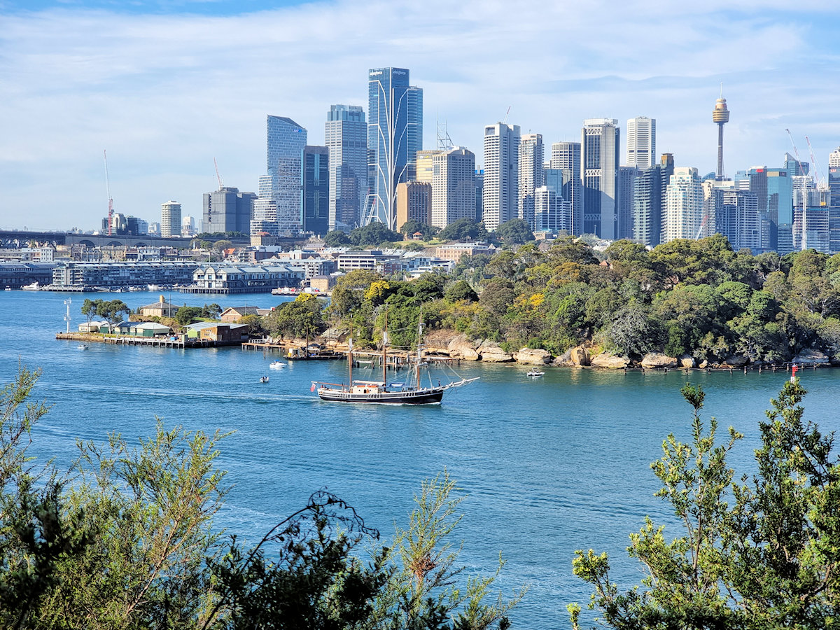
    Meandering through the park, several paths lead you through the revegetated bush. Viewing platforms from the upper section provide fantastic vantage points to see Sydney Harbour as well as the bridge and city. From here you can also look down to where giant fuel tanks once stood but have been transformed into green circles.

    At the southern end of the park, two old wooded piers, one of which has collapsed are still visible in Berrys Bay. From here we walked to the Coal Loader and its derelict Coal Loading Wharf before finishing our day at Balls Head Reserve.

    Our photos are available for purchase on

    To see what else there is to do in New South Wales, please see some of our other stories.

  • Balls Head Reserve Sydney Australia

    Balls Head Reserve Sydney Australia

    Balls Head Reserve Sydney Australia

    Located on the northern side of Sydney Harbour, Balls Head Reserve is a scenic reserve offering breathtaking views of the harbour city and bridge. Winding tracks through regenerated native bushland let you experience the Australian bush without leaving Sydney.

    History

    The reserve was named after Henry Lidgbird Ball, who was a Royal Navy officer and the captain of HMS Supply during the First Fleet’s arrival in 1788.

    During the 19th century, the area was utilized for quarrying and later for shipbuilding purposes. The remnants of the quarrying activity are still visible within the reserve. To the north of the reserve, Balls Head Coal Loader was an important export point for coal. The coal wharf and load out tunnels are still present and make a great addition to a visit to the area.

    Getting there

    Getting to Balls Head Reserve is relatively straightforward. We used the train and walked through Carradah Park and Balls Head Coal Loader before going to the reserve.

    • By public transport: Take a train to Waverton station and then enjoy a pleasant 15-20 minute walk through the picturesque streets of Waverton to reach the reserve. Alternately, walk through Carradah Park for more views of the harbour and see the rehabilitated BP site.
    • By car: It’s recommended to arrive early to secure a spot because there is limited street parking available.

    Remember to check the current public transport schedules and any restrictions in place before planning your visit.

    Balls Head Reserve

    We entered the reserve through the tunnels from the old coal loader. This is a great way to enter the reserves because you walk from an industrial area to a rehabilitated bush environment. Although the tunnel is well lit the walkway is rough, so watch your footing.

    Following the narrow track around the headland, we had some amazing views of the harbour. Several lookout provide great places to relax and take in the views. One even has a weather shelter carved from a large boulder. We brought some snacks and drinks, so this was a great place to stop and refuel while admiring the views. We were lucky to be there when one of the sailing ships went past, returning from one of its day trips.

    The track varies from a wide shared roadway to narrow dirt tracks, so it’s a good idea to wear good shoes if you want to see the whole area. Several picnic spots with tables benches and toilets make it a great place to spend a few relaxing hours.

    Coal Loading Tunnel
    Coal Loading Tunnel

    Our photos are available for purchase on

    To see what else there is to do in New South Wales, please see some of our other stories.

  • Manly to North Head Walk

    Manly to North Head Walk

    The walk from Manly to North Head takes you past some beautiful beaches with views over the coast, through coastal scrub and passes old fortifications. Finally ending at the entrance to Sydney Harbour, it has spectacular views of the city.

    Getting There

    The easiest way to get to Manly is to take the Manly ferry from Circular Quay. If you’re new to Sydney, this is an attraction in itself, because the Sydney Harbour ferries form an important part of the local public transport. During the ferry ride, you get some brilliant views of the Opera House and Harbor Bridge as well as all the other boat traffic on the water.

    Start of the Walk

    Catching the Manly Ferry from Circular Quay, we arrived at Manly Wharf at 9:30 am. We planned our walk to take us along the shore to Shelly Beach where we would follow a track to the Barracks Precinct. Not only would this give us views over the coast but take us past some old fortifications and gun emplacements.

    From the Manly wharf, we walked down The Corso, which is a pedestrian mall leading to the beach.

    Manly Beach

    One of the most popular Sydney beaches, Manly Beach is a great place for a swim or relaxing on the sand. We bought a coffee at a kiosk near the south end of the beach before starting the walk.

    Manly Beach
    Manly Beach

    Manly to Shelly Beach

    Starting at the south end of Manly Beach, the path follows the coastline, which is rocky until you reach Shelly Beach. There are plenty of places with places to look up and down the coast and back to Manly, giving you some amazing views.

    Along the way look out for small metal sculptures of local wildlife. These have been placed on the rocks next to the path.

    About halfway to Shelly Beach, Fairy Bower Pool is a protected ocean pool where you can swim. The pool is also decorated with a sculpture of two fairies.

    Shelly Beach

    Shelly Beach is a secluded and serene crescent-shaped beach surrounded by nice shady trees. As well as a grassed area to relax on it has a kiosk where you can buy refreshments before continuing the walk.

    From Shelly Beach, the track goes uphill to head along the cliffs to the south.

    Shelly Beach Manly Sydney Australia
    Shelly Beach

    Shelly Headland Lookout

    Perched on a rocky outcrop overlooking the ocean, this Shelly Headland Lookout provides an ideal spot for photographers because of the wonderful views along the coast. During the whale migration season, it’s also an ideal point to watch them swimming past.

    Coastal view looking north back to Manly Manly to North Head Walk
    Coastal view looking north back to Manly

    Shelly Beach to the Barracks Precinct

    After the flat walk from Manly the track becomes rougher and steeper. From here the track climbs uphill to reach the cliff tops. Winding through the coastal vegetation, it is not as busy as the first section because it is a more difficult walk. We loved this section, as the walk through the bush was much more peaceful.

    At the top of the cliffs, old fortifications dating from the Second World War and earlier can be seen. The track even goes through one of the old walls built to defend the area.

    Barracks Precinct

    The Barracks Precinct at North Head is a historically significant site that served as a military base from the mid-19th century to the mid-20th century. It played a crucial role in the defence of Sydney Harbor and housed various military units over the years.

    The Barracks Precinct has well-preserved sandstone buildings, which showcase the architectural style of the time. It includes several barracks, officers’ quarters, mess halls, and maintenance buildings. These structures provide a glimpse into the daily lives of soldiers stationed at North Head.

    Today, the Barracks Precinct has been repurposed as a heritage site and is open to the public for exploration. Visitors can wander through the historic buildings, learn about the site’s military history through information boards which are dotted around the area.

    In this area and continuing to North Head, the walking tracks are generally well paved and often consists of boardwalks or paved roads. When we visited, the banksias were in flower adding a touch of colour to the walk.

    Fortifications

    Many of the original fortifications were dismantled and the guns sold for scrap when they were no longer needed. Fortunately, some are still in place so that visitors can see them. Several large gun emplacements are open to the public, but when we visited others were being repaired.

    A great way to get a feel for the area’s past is to take the underground tunnels tour. We did this several years ago and highly recommend it. You walk through the tunnels and underground sections of the fortifications as well as getting into areas the general public cannot access.

    Memorial Walk

    Winding through the coastal vegetation, the Memorial Walk commemorates Australia’s military heritage. Not only are there great sandstone memorials but the path is inlaid with bricks commemorating individuals or military units.

    Fairfax Lookout

    The end of our walk took us to Fairfax Lookout with its stunning views of Sydney and Sydney Harbour. The site was named after Sir James Fairfax, a prominent Australian businessman and philanthropist.

    View of Sydney and the Harbour from Fairfax Lookout Manly to North Head Walk
    View of Sydney and the Harbour from Fairfax Lookout

    Other Places to See in North Head

    If you have time, Q Station, the old Sydney Quarantine Station is worth a visit. We did a guided tour here some time ago, which took us through the history of the site and most of its buildings. The old quarantine station cemetery is also a great place to see.

    Getting Back

    After finishing our walk, we decided to catch the bus back to the wharf as it stops right outside. Alternatively, you could walk back via Q Station. We had an excellent tour there a few years ago and highly recommend a visit.

    Our photos are available for purchase on

    To see what else there is to do in New South Wales, please see some of our other stories.